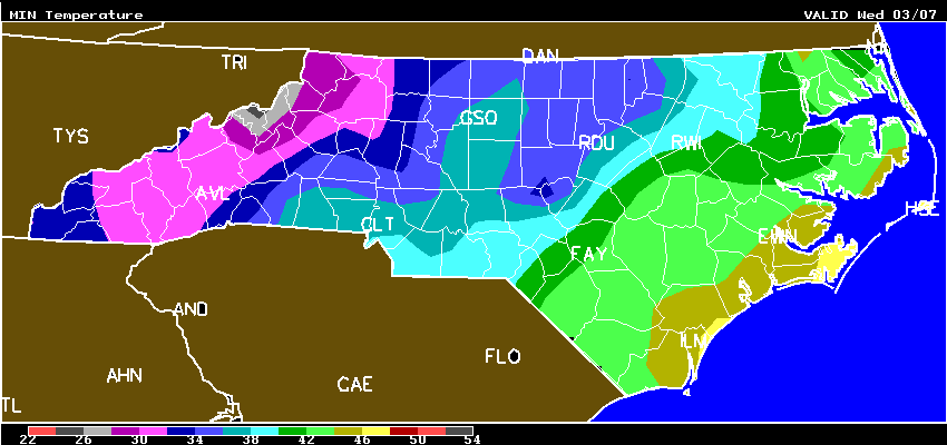
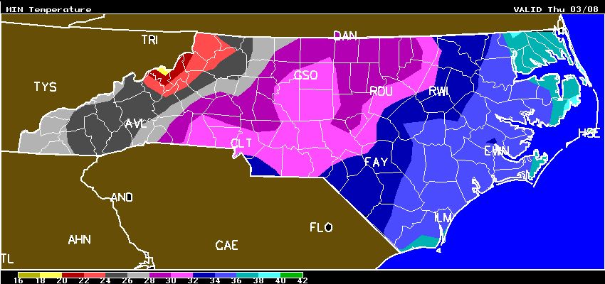
NC Min Temp Maps Wed-Thur-Fri and Frost / Freeze Forecast From AWIS (5:20pm, Tue., March 6, 2018)
go.ncsu.edu/readext?514492
en Español / em Português
El inglés es el idioma de control de esta página. En la medida en que haya algún conflicto entre la traducción al inglés y la traducción, el inglés prevalece.
Al hacer clic en el enlace de traducción se activa un servicio de traducción gratuito para convertir la página al español. Al igual que con cualquier traducción por Internet, la conversión no es sensible al contexto y puede que no traduzca el texto en su significado original. NC State Extension no garantiza la exactitud del texto traducido. Por favor, tenga en cuenta que algunas aplicaciones y/o servicios pueden no funcionar como se espera cuando se traducen.
Português
Inglês é o idioma de controle desta página. Na medida que haja algum conflito entre o texto original em Inglês e a tradução, o Inglês prevalece.
Ao clicar no link de tradução, um serviço gratuito de tradução será ativado para converter a página para o Português. Como em qualquer tradução pela internet, a conversão não é sensivel ao contexto e pode não ocorrer a tradução para o significado orginal. O serviço de Extensão da Carolina do Norte (NC State Extension) não garante a exatidão do texto traduzido. Por favor, observe que algumas funções ou serviços podem não funcionar como esperado após a tradução.
English
English is the controlling language of this page. To the extent there is any conflict between the English text and the translation, English controls.
Clicking on the translation link activates a free translation service to convert the page to Spanish. As with any Internet translation, the conversion is not context-sensitive and may not translate the text to its original meaning. NC State Extension does not guarantee the accuracy of the translated text. Please note that some applications and/or services may not function as expected when translated.
Collapse ▲AWIS Weather Services, Inc. North Carolina Frost/Freeze Forecast Produced at 306 p.m. CST on Tue Mar 6 2018 ... Forecast for Tonight ... Northeast NC Coast Currituck/Camden/Pasquotank/Tyrrell Counties *** No Frost And/Or Freeze Danger Tonight *** Lowest Temperatures: 41 - 47 Elizabeth_City Min 43 Extended Forecast: Range of Lowest Min Temperatures in the Above Zones Min Temps Valid For Morning of Given Date (May NOT include ALL cold pockets) 03/08/18 03/09/18 03/10/18 03/11/18 03/12/18 03/13/18 -------- -------- -------- -------- -------- -------- 35 - 41 32 - 38 35 - 42 42 - 48 39 - 45 36 - 42 -------- East Central/SE NC Coast Carteret/Pamlico Counties *** No Frost And/Or Freeze Danger Tonight *** Lowest Temperatures: 45 - 49 Morehead_City Min 47 Extended Forecast: Range of Lowest Min Temperatures in the Above Zones Min Temps Valid For Morning of Given Date (May NOT include ALL cold pockets) 03/08/18 03/09/18 03/10/18 03/11/18 03/12/18 03/13/18 -------- -------- -------- -------- -------- -------- 35 - 38 31 - 35 32 - 38 43 - 47 42 - 45 36 - 40 -------- Southeast NC NWS FORECAST ZONES 87-90,96-101 **** LITTLE IF ANY FROST DUE TO CLOUDS **** Lowest Temperatures: 40 - 50 Elizabethtown Min 45 Range Dewpoint Temps: 38 - 51 Range Wetbulb Temps: 41 - 52 AVG Wind Direction/Speed: SW 9 AVG Sky Condition: Cloudy Extended Forecast: Range of Lowest Min Temperatures in the Above Zones Min Temps Valid For Morning of Given Date (May NOT include ALL cold pockets) 03/08/18 03/09/18 03/10/18 03/11/18 03/12/18 03/13/18 -------- -------- -------- -------- -------- -------- 32 - 37 29 - 33 35 - 39 44 - 49 39 - 44 35 - 38 -------- North-Central NC Franklin County Area **** FREEZE COLD LOCATIONS **** **** LITTLE IF ANY FROST DUE TO CLOUDS **** Lowest Temperatures: 32 - 43 Louisburg Min 32 Durations at/below 32: 0 - 1 Range Dewpoint Temps: 32 - 41 Range Wetbulb Temps: 34 - 42 AVG Wind Direction/Speed: NE 3 Long Periods of Calm AVG Sky Condition: Cloudy Extended Forecast: Range of Lowest Min Temperatures in the Above Zones Min Temps Valid For Morning of Given Date (May NOT include ALL cold pockets) 03/08/18 03/09/18 03/10/18 03/11/18 03/12/18 03/13/18 -------- -------- -------- -------- -------- -------- 27 - 35 24 - 31 28 - 35 34 - 44 32 - 40 29 - 36 -------- North/Central NC Alamance County Area **** NEAR FREEZING COLD LOCATIONS **** **** LITTLE IF ANY FROST DUE TO CLOUDS **** Lowest Temperatures: 33 - 39 Graham_AG Min 36 Range Dewpoint Temps: 33 - 41 Range Wetbulb Temps: 35 - 42 AVG Wind Direction/Speed: W 4 Long Periods of Calm AVG Sky Condition: Cloudy Extended Forecast: Range of Lowest Min Temperatures in the Above Zones Min Temps Valid For Morning of Given Date (May NOT include ALL cold pockets) 03/08/18 03/09/18 03/10/18 03/11/18 03/12/18 03/13/18 -------- -------- -------- -------- -------- -------- 28 - 33 25 - 30 28 - 34 36 - 41 33 - 39 29 - 34 -------- South/Central NC Richmond County Area **** LITTLE IF ANY FROST DUE TO CLOUDS **** Lowest Temperatures: 36 - 45 Ellerbe Min 45 Range Dewpoint Temps: 36 - 47 Range Wetbulb Temps: 37 - 48 AVG Wind Direction/Speed: SW 6 Periods of Calm AVG Sky Condition: Cloudy Extended Forecast: Range of Lowest Min Temperatures in the Above Zones Min Temps Valid For Morning of Given Date (May NOT include ALL cold pockets) 03/08/18 03/09/18 03/10/18 03/11/18 03/12/18 03/13/18 -------- -------- -------- -------- -------- -------- 29 - 34 26 - 32 34 - 37 41 - 46 37 - 41 31 - 37 -------- Interior/EC-SE NC Wayne County Area **** LITTLE IF ANY FROST DUE TO CLOUDS **** Lowest Temperatures: 40 - 47 Goldsboro_AG Min 44 Range Dewpoint Temps: 40 - 48 Range Wetbulb Temps: 45 - 48 AVG Wind Direction/Speed: W 8 AVG Sky Condition: Cloudy Extended Forecast: Range of Lowest Min Temperatures in the Above Zones Min Temps Valid For Morning of Given Date (May NOT include ALL cold pockets) 03/08/18 03/09/18 03/10/18 03/11/18 03/12/18 03/13/18 -------- -------- -------- -------- -------- -------- 32 - 36 30 - 32 32 - 36 42 - 45 38 - 41 35 - 39 -------- For more detailed information visit www.awis.com or call 888-798-9955. Copyright 2018 AWIS Weather Services, Inc. All rights reserved.